Deep-Time Palaeo-GIS Explorer
The Deep-Time Palaeo-GIS Explorer is a specialised spatial reconstruction module for analyzing long-term environmental change, palaeoclimate shifts, hydrological transformations, and prehistoric human engagement with the landscape in the Dead Sea Basin and Southern Levant.
Spanning time horizons from the Last Glacial Maximum (20,000 BP) through the Pre-Pottery Neolithic (PPN) to the Middle Bronze Age (3,500 BP), the module enables researchers to reconstruct ancient lake shorelines (Lake Lisan), iso-hyet shifts, vegetation biomes, and prehistoric settlement distributions.
Access: The Deep-Time Palaeo-GIS module requires the Palaeo-GIS workspace unlock. Request access on your Account page.
When to use it
- Reconstruct ancient lake extents. Visualize Lake Lisan at its $-160\text{ m}$ MSL highstand during the LGM versus its regression during the Early Holocene pluvial.
- Analyze prehistoric settlement footprints. How did PPNB agricultural communities inscribe themselves across newly exposed rift valley soils as lake waters receded?
- Model palaeo-precipitation shifts. Evaluate catchment viability under a $+40%$ regional rainfall increase during the Early Holocene.
- Trace long-term human-environment interactions. Examine how human settlements adapted to mid-Holocene desiccation across successive cultural epochs.
Anatomy of the interface
The Palaeo-GIS workspace integrates a Palaeo-Environmental Control Sidebar on the left with a 3D terrain-enabled Palaeo-Map Canvas on the right.
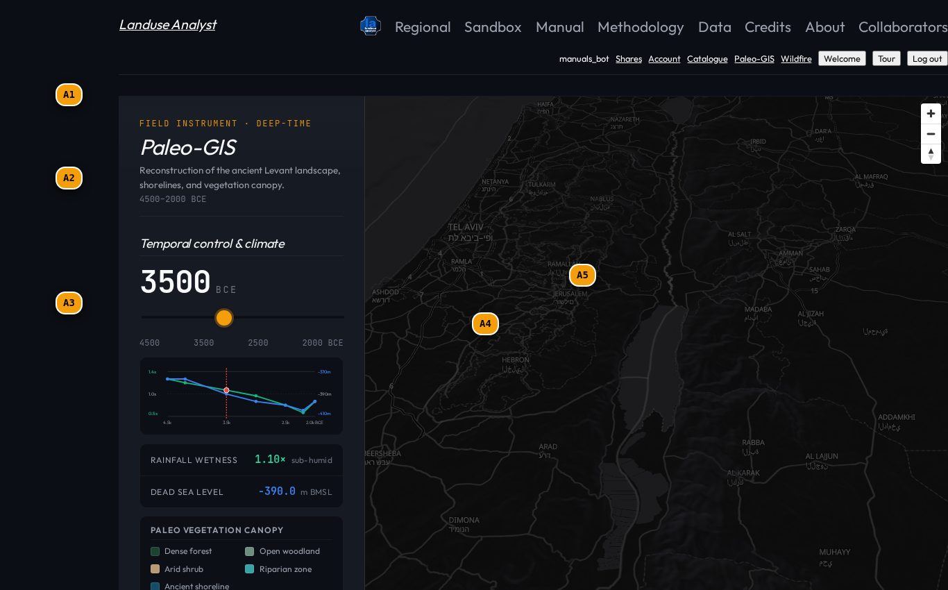
| Tag | Control | What it does |
|---|---|---|
A1 | Time Horizon & Epoch Picker | Select climate epoch: Last Glacial Maximum, Terminal Pleistocene, Early Holocene Pluvial, or Mid-Holocene Arid. |
A2 | Hydrological Reconstruction | Set Dead Sea / Lake Lisan water level ($-160\text{ m}$ to $-400\text{ m}$ MSL) and precipitation offset sliders ($+50%$ to $-30%$). |
A3 | Archaeological Filters | Toggle settlement distribution layers by period: Natufian, PPNA/PPNC, Ghassulian Chalcolithic, EB I-III, and MB II. |
A4 | Palaeo Lake Lisan Polygon | Reconstructed water body extent corresponding to the selected lake level (e.g. $-290\text{ m}$ during the Early Holocene). |
A5 | Archaeological Site Markers | Georeferenced prehistoric settlement points with popups displaying site area (ha), radiocarbon dates, and material culture attributes. |
Supported palaeo-climate epochs
Critical to this approach is the understanding that ancient landscapes were not static baselines. Considering as many environmental variables as possible — lake level, precipitation, and biome expansion — can only increase the credibility of any inferences drawn.
| Climate Epoch | Horizon | Lake Lisan Level | Regional Rain | Vegetation & Biome |
|---|---|---|---|---|
| Last Glacial Maximum (LGM) | 24,000 – 18,000 BP | $-160\text{ m}$ (Highstand) | $+60%$ vs present | Steppe / Conifer Woodland in Highlands |
| Terminal Pleistocene (Natufian) | 15,000 – 11,700 BP | $-240\text{ m}$ (Regressing) | $+30%$ vs present | Oak-Pistacia Open Park Forest |
| Early Holocene Pluvial (PPN) | 11,700 – 8,200 BP | $-290\text{ m}$ (Pluvial) | $+40%$ vs present | Mediterranean Evergreen Forest Expansion |
| Mid-Holocene Desiccation (EB) | 6,000 – 4,200 BP | $-390\text{ m}$ (Desiccating) | Present baseline | Mediterranean Scrub / Desert Steppe |
Walkthrough: Reconstructing the Early Holocene Pluvial
Follow these steps to conduct a palaeo-environmental reconstruction:
1. Select the Early Holocene Epoch
- Open the Time Horizon Picker (
A1). - Select Early Holocene Pluvial (10,000 – 8,000 BP).
2. Configure Lake Lisan Water Level
- In Hydrological Reconstruction (
A2), verify the lake level is set to -290 m MSL. - Observe how the map canvas (
A4) updates to draw the expanded Lake Lisan shoreline covering the Jordan Rift Valley.
3. Overlay Pre-Pottery Neolithic Sites
- Expand Archaeological Filters (
A3). - Check PPNB / PPNC Settlements (N=142).
- Click on Jericho (Tell es-Sultan) (
A5) to inspect its early agricultural catchment parameters.
Related Manuals
- Agricultural Catchment Model — Run catchment models on palaeo-reconstructed sites.
- Data Catalogue — Inspect raw palaeo-climate rasters and DEM layers.
- Glossary — Definitions for Lake Lisan, Pluvial periods, and Iso-hyet contours.