Regional Analysis Console
The Regional Analysis Console aggregates single-site catchment models into regional spatial network evaluations. It assesses multi-settlement population pressure, overlapping agricultural catchments, competition indices, and regional caloric balances across defined geographic zones.
By partitioning contested territory via Voronoi tessellation or friction-weighted cost boundaries, the Regional Console identifies land competition hotspots and estimates regional carrying capacities across the Southern Levant.
Access: The Regional Analysis Console is open to all visitors at
/regional.
When to use it
- Evaluate regional population pressure. Aggregate settlement networks across the Southern Levant during the Early Bronze Age ($3500-3000\text{ BC}$) to test whether land availability constrained urbanisation.
- Analyze catchment competition. Identify territorial overlap zones where adjacent sites compete for the same arable soil.
- Compare territorial partitioning rules. Contrast simple Voronoi geometric bisectors against terrain-sensitive friction-weighted cost partitions.
- Compute regional carrying capacity. Estimate aggregate caloric yields and human support capacities across entire hydrological basins.
Anatomy of the interface
The Regional Console features a Region Control Sidebar on the left and a Multi-Site Map Viewport on the right.
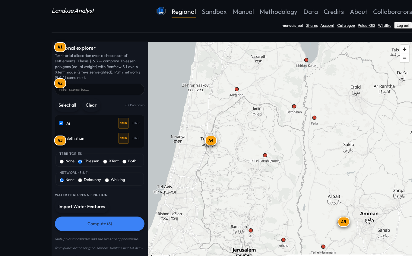
| Tag | Control | What it does |
|---|---|---|
A1 | Region & Period Filter | Select target geographic region (Southern Levant, Dead Sea Basin, Northern Jordan Valley) and cultural period. |
A2 | Regional Demographics | Summary of total aggregated population, combined arable land demand ($\text{ha}$), and regional population density. |
A3 | Catchment Overlap Settings | Configure boundary partitioning rules: Voronoi Tessellation, Friction-Weighted Cost Partition, or Shared Common Land. |
A4 | Aggregated Site Catchments | Map display showing individual site catchment polygons with colour-coded land competition overlap zones. |
A5 | Regional Summary HUD | High-level metrics showing active settlement count, overall regional surplus/deficit, and land pressure classification. |
Catchment competition & territory partitioning
Critical to this approach is the understanding that human settlements do not exist in isolation. Considering as many regional variables as possible — site density, terrain friction, and inter-site competition — can only increase the credibility of any historical inferences drawn.
When adjacent settlement catchments overlap, Landuse Analyst applies one of three partitioning rules:
- Voronoi Geometric Partitioning: Divides contested land along Euclidean bisectors between site centroids.
- Friction-Weighted Cost Partitioning: Allocates contested cells to the site with the lowest travel time ($T_{\text{walk}}$), accounting for intervening slope gradients and rivers.
- Shared Common Grazing: Allows pastoral grazing rings to overlap while enforcing strict non-overlapping boundaries on intensive arable land.
$$\text{Competition Index } (\chi) = \frac{\text{Area of Overlapping Catchments}}{\text{Total Regional Arable Area}} \times 100%$$
Walkthrough: Evaluating Early Bronze Age Regional Pressure
Follow these steps to analyze regional land pressure:
1. Select Region and Period
- In Region & Period (
A1), select Southern Levant and Early Bronze Age I (3500–3000 BC). - The map displays 42 settlement sites (
A4) across the Jordan Valley and highlands.
2. Configure Partitioning Method
- In Catchment Overlap Settings (
A3), select Friction-Weighted Cost Partition.
3. Read Regional Metrics
- Inspect the Regional Summary HUD (
A5):- Total Population: 48,600 inhabitants.
- Arable Demand: 18,200 ha.
- Competition Overlap Index: $14.2%$ (Moderate competition in Northern Jordan Valley cluster).
- Regional Net Balance: $+14.2%$ caloric surplus across the regional network.
Related Manuals
- Agricultural Catchment Model — Individual site catchment solver.
- Data Catalogue — Regional archaeological site databases.
- Glossary — Definitions for Voronoi tessellation, competition index, and carrying capacity.