Wildfire Simulation & Fuel Integration
The Wildfire Simulation & Fuel Integration module provides high-resolution fire behaviour modelling integrated into Landuse Analyst. It enables researchers and land managers to simulate fire spread across real terrain, translate fuel classifications, and evaluate firefighter escape safety.
I built the wildfire engine to link fire behaviour directly to hominin mobility and landscape accessibility. The module supports two solvers: the built-in in-process Hexagonal Cellular Automaton (HCA) and the remote WISE Wave Propagation Engine.
Access: This module requires the Wildfire workspace unlock. Request access on your Account page.
When to use it
- Simulate fire spread on real terrain. Drop an ignition pin, set wind vectors, and animate time-stepped fire perimeter growth.
- Evaluate firefighter & actor escape safety. Toggle the No-Escape Overlay to highlight cells where fire rate of spread (ROS) beats a person walking away on foot.
- Compare solvers. Contrast the fast in-process Hexagonal Cellular Automaton (HCA) against a landscape-scale wave propagation run using the remote WISE physics engine.
- Assess crown fire potential. Model crown fire initiation and active crowning based on canopy bulk density and base height.
Anatomy of the interface
The Wildfire Simulator consists of a Simulation Control Sidebar on the left and a 3D-enabled Map Canvas on the right.
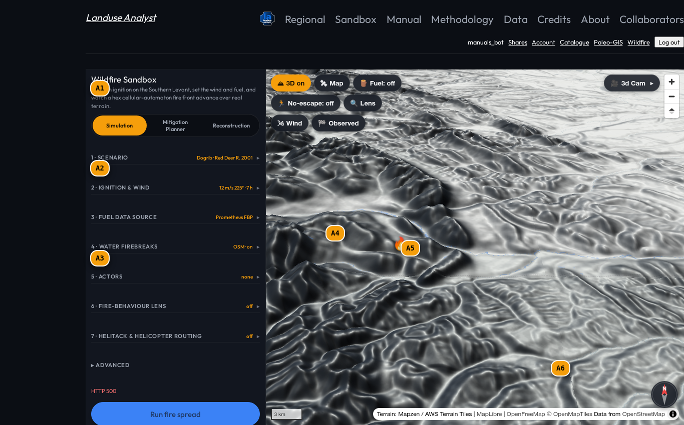
| Tag | Control | What it does |
|---|---|---|
A1 | Ignition & Wind Accordion | Set wind speed ($\text{m/s}$), wind direction bearing ($0-360^\circ$), duration ($0-24\text{ h}$), and temporal wind trace schedules. |
A2 | Engine & Fuel Selector | Pick simulation engine (HCA vs WISE) and fuel dataset (LANDFIRE FBFM40, CFFDRS FBP, WorldCover). |
A3 | Safety & Overlays Accordion | Toggle No-Escape Overlay (where fire $\text{ROS} > \text{walking speed}$), Helitack dip sites, and human actor evacuation statuses. |
A4 | Ignition Point Marker | Draggable flame pin setting the fire start location on burnable terrain. |
A5 | No-Escape Zone Highlight | Red map overlay highlighting cells where fast fire spread cuts off foot evacuation. |
A6 | Fire Spread Results HUD | Summary panel displaying total burned area ($\text{km}^2$), maximum rate of spread ($\text{m/min}$), and crown fire fraction. |
Simulation Solvers: HCA vs. WISE Engine
The question, then, is which solver best serves your analysis:
| Feature / Solver | Hexagonal Cellular Automaton (HCA) | WISE Wave Propagation |
|---|---|---|
| Solver Architecture | In-process hexagonal cellular automaton | Landscape wave-front physics solver (Remote Compute) |
| Execution Speed | Instantaneous ($<1\text{ s}$) | 5–15 seconds (Remote compute node) |
| Interactive Features | All features (water barriers, temporal wind, actors, helitack) | Core physics wave front & perimeter only |
| Crown Fire Model | Full Van Wagner crown transition & fraction | Standard Canadian FBP crown model |
| Spotting & Smouldering | Subsurface KBDI & ember physics spotting | Perimeter spread wave |
Walkthrough: Running a Wildfire Scenario
Follow these steps to run a fire-spread simulation:
1. Set Ignition & Wind Conditions
- Drag the Ignition Pin (
A4) to a forested location on the map. - In Ignition & Wind (
A1), set Wind Speed to 12 m/s and Bearing to 270° (blowing from west to east). - Set Duration to 3.0 hours.
2. Configure Fuel & Engine
- In Engine & Fuel (
A2), select Cellular Automaton (HCA). - Select LANDFIRE FBFM40 fuel source.
3. Launch & Read Results
- Click LAUNCH SIMULATION.
- Watch the fire front animate outward from the ignition point (
A4). - Toggle the No-Escape Overlay (
A3,A5) to identify hazardous terrain sectors where fire outruns personnel on foot.
Related Manuals
- Barriers & Travel-Time Sandbox — Tobler walking velocity models used in no-escape evaluations.
- Data Catalogue — Inspect fuel rasters and canopy density layers.
- Glossary — Definitions for rate of spread (ROS), crown fire, and HCA.