Getting Started
Welcome to Landuse Analyst, an open computational framework for agricultural catchment analysis, palaeo-environmental reconstruction, travel-time cost modelling, and regional spatial analytics.
I built Landuse Analyst to bridge the seam between agronomic modelling and landscape archaeology. Whether you are evaluating Early Bronze Age agricultural sustainability in the Southern Levant, modelling travel friction across rugged terrain using Tobler’s Hiking Function, or inspecting spatial datasets in the catalogue, this manual maps the workspace interface control-by-control.
Stance: Landuse Analyst operates on the conviction that considering as many variables as possible — terrain slope, soil fertility, crop yields, labor constraints, and hydrological barriers — can only increase the credibility of any historical inferences drawn.
Platform Architecture & Navigation
Landuse Analyst pairs a responsive web interface with a high-performance spatial computation engine. The interface is organised around dedicated tools accessible via the top navigation bar.
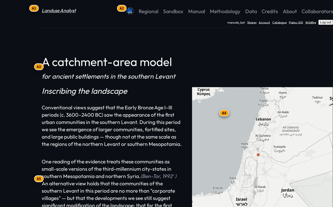
| Tag | Interface Element | Purpose & Behaviour |
|---|---|---|
A1 | Header Masthead | Displays the workspace title, volume edition, and section metadata (un-hidden in Notebook theme). |
A2 | Top Navigation Bar | Direct links to primary modules: Model, Regional, Sandbox, Manual, Data, Credits, About, and Collaborators. |
A3 | Auth & Account Chip | Reports user login status, assigned workspace unlocks (Admin, Palaeo, Wildfire), and account controls. |
A4 | Control Sidebar | Parameter configuration panel for site selection, population sliders, crop allocation, and friction settings. |
A5 | Map Viewport | Full-viewport interactive GIS canvas powered by MapLibre GL — rendering catchment rings, elevation contours, and friction rasters. |
A6 | Map Legend & Overlay Rail | Layer toggles for switching basemaps, friction overlays, 3D terrain pitch, and catchment boundary geometries. |
Dual Design Systems: Notebook vs. Modern Theme
Landuse Analyst supports two curated design themes:
- Notebook Theme (Field Log): An academic, vintage field-journal aesthetic featuring IM Fell DW Pica headers, Roman date stamps, wax-seal ornaments, and paper-textured background styling — designed to read like a real field-log table of contents.
- Modern Theme: A sleek, high-contrast dark theme optimized for GIS analysis with vibrant HSL color accents, glassmorphic card overlays, and clean sans-serif typography (Outfit & Inter).
You can toggle between themes at any time using the Theme Switcher in the footer or modal settings.
Core Workflow Overview
A typical session in Landuse Analyst follows a 4-step sequence:
- Pick or Define a Location: Select a benchmark archaeological site (e.g. Tell esh-Shuna North, Jericho, Bab edh-Dhra) from the pre-populated catalogue — or click anywhere on the map to place a custom origin pin.
- Configure Demographic & Agricultural Baselines: Set settlement population, daily per-capita caloric demand, crop allocation fractions (wheat, barley, pulses, olives), and fallow ratios.
- Select Propagation Geometry & Terrain Penalties: Choose between Octagonal Cell cost propagation or Radial Euclidean distance, and select slope penalty functions (e.g. Minetti metabolic cost).
- Execute & Interpret Results: Run the spatial solver to compute arable catchment boundaries, caloric self-sufficiency percentages, labor hours required, and travel-time contours.
Workspace Unlocks & Permissions
Certain specialised tools require workspace authorization:
- Open Access: Agricultural Catchment Model, Barriers Sandbox, Data Catalogue, Methodology, and Regional summaries are open to all visitors.
- Palaeo-GIS Workspace: Deep-Time Palaeo-GIS module requires the Palaeo unlock (granted to registered researchers).
- Wildfire Workspace: Wildfire Simulation & Fuel Integration module requires the Wildfire unlock.
To request access to specialised workspaces, navigate to the Account page or contact an administrator.
Related Manuals
- Agricultural Catchment Model — Run your first catchment simulation.
- Barriers & Travel-Time Sandbox — Model travel friction and river crossings.
- Methodology & Formulations — Read the mathematical equations governing the engine.
- Glossary — Definitions for key spatial, demographic, and agronomic terms.